Avalanche Journal Blog
Blog Home All Blogs
This is the blog of the Avalanche Journal. Here you will be able to read articles that appeared in past editions of the Avalanche Journal. Our digital archives currently go back to spring 2005 (volume 72) and we will be posting one article each week from a select issue.


Search all posts for:   


Top tags: avalanche journal  avalanche forecasting  snowpack tests  avalanche  avalanche control  avalanche education  avalanche research  snow science  avalanche incident  bruce jamieson  case study  companion rescue  ice climbing  kootenay pass  laura maguire  ministry of transportation  MOTI  roger atkins  strategic mindset  wren mcelroy  airbag  applied snow and avalanche research centre  asarc  aspen  AST 1  ates  atmospheric river  avalanche canada  avalanche detection  avalanche fences 

Can Solar Warming Contribute to Dry Slab Avalanches?

Posted By Administration, January 20, 2021

From volume 84, spring 2008

By Thomas Exner1 and Bruce Jamieson2
ASARC – Applied Snow and Avalanche Research, University of Calgary
1 Dept. of Geoscience, University of Calgary
2 Dept. of Civil Engineering, University of Calgary


Many people associate snow pack warming with spring-like conditions, when snow temperatures are close to 0°C and the likelihood of wet avalanches increases rapidly as soon as the sun softens up the melt-freeze-crust that often forms during cool nights. This is a common scenario in spring, when signs of warming, such as relatively warm air temperatures, strong solar radiation, and moist surface snow are easy to observe. But, what happens to a cold, dry snow pack that warms up significantly at air temperatures below zero?

In this article we discuss a few concepts of stability changes caused by daytime warming and summarise results from reported avalanches mainly caused by solar warming of a dry snowpack. These cases are quite rare, but under the right conditions warming can be the significant factor decreasing stability. According to a Swiss study (Harvey and Signorell, 2002) in 20% of 128 avalanche accidents in the Swiss Alps, daytime warming was the only factor contributing to avalanching. On those days no significant amount of new snow or recent wind loading was reported. Of course, maybe in some of those cases there may have been just a lingering instability, which could have been triggered by a skier regardless of the warming. However, the 20% suggest a significant correlation to the influence of warming.


Figure 1: Figure 1. This dry slab avalanche was triggered on a cold, sunny day by a skier on a steep south-west facing aspect. Solar warming may have contributed to this release. (photo: ASARC)


What are the sources of warming that can rapidly increase the temperature of near surface layers?
The main warming sources that effectively are able to increase avalanche danger are solar warming, rain, and warm, strong winds. Rain is probably the most efficient way of adding heat to the snowpack (Marshall and others, 1999). It destabilizes the snow pack in a short time, can penetrate down to deep layers, and affects all aspects. Luckily, mid-winter rain events are rare in alpine regions in most places in Western Canada. Warm, dry winds, such as the Chinook are known to cause rapid warming of the near surface layers and may reduce snow pack stability. But, these warm wind events are infrequent, except on the eastern slopes of the Canadian Rockies.

The most frequent cause of near surface warming seems to be direct solar radiation. It can warm up the upper layers of the snow pack rapidly within hours and affect the stability of the snowpack down to about 30 to 50 cm (McClung and Schaerer, 2006, p.38). By softening the surface layers, loads (e.g. skiers or snow boarders) may even affect deeper layers. Thin clouds may intensify the heating effect by trapping radiation between the snow pack and the clouds (greenhouse effect). 

The effect of time
Usually, warming of a dry snowpack is associated with increased settlement of the snow pack, and non-persistent (storm snow) weak layers are believed to be stabilizing under these conditions. This seems to be the case as long as the settlement happens slowly and gradually (McClung and Schweizer, 1996). Settlement and creep are always connected with a deformation of the snowpack, and snow as a material can adjust to slow changes in deformation without damage. However, fast deformation, as sometimes observed during rapid warming events, can result in collapse of the snow micro-structure (bonds are breaking faster than new bonds are forming), and a layered snowpack may release slab avalanches.

So, slow warming and settlement of the snowpack usually promotes stability. But, of course, there is an exception to this rule. Imagine for example a surface hoar layer, buried under a layer of low density snow with low cohesion (Fig. 2). No matter how hard a skier, boarder or snowmobiler hits this layer there is no slab to release. But with ongoing settlement, even when slow and gradual, the overlying layer(s) will increase in stiffness and density (become “slabby”). Now it may not take a lot to trigger and propagate a fracture in the surface hoar layer, and release a slab avalanche. This process requires a pre-existing persistent weak layer, such as the surface hoar layer.

In most cases when rapid solar warming, within a few hours or so, increases avalanche danger the slab/weak layer combination is mostly already like a “loaded gun.” The warming speeds up the creep of the slab on the weak layer just enough to possibly trigger a natural slab avalanche. Keep in mind we are still talking about a dry, sub-freezing snowpack. Once the snow surface starts to melt we are dealing with moist or wet point releases, which are a different story not addressed in this article. However, there are few cases where rapid solar warming significantly decreased stability, even though an obvious weak layer was not observed. The following section summarizes the conditions when this phenomenon was observed.


Figure 2. Even a prominent surface hoar layer with loose, low density snow on top is not releasable (left); neither by a skier nor as a natural avalanche. After the surface layer settles into a slab a fracture can propagate along the weak layer and release a slab avalanche (right). Daytime warming accelerates the settlement process and may act as a trigger.

Low density snow and rapid solar warming
According to the results of a survey conducted amongst 35 experienced avalanche practitioners in the fall of 2006, numerous reports of solar warming related avalanches followed a similar pattern. In all of these cases obvious signs of instability (shooting cracks, whumpfing and skier-triggered avalanches) developed during a short period of strong solar warming after the snow pack initially appeared to be stable and, interestingly, no obvious weak layer was observed initially. A few of these cases were reported by mechanised skiing operations, where a run was skied several times during the warming period. Snowpack observations ranged from no signs of instability on the first run to shooting cracks and triggered slabs within hours on the following runs. The following list summarises conditions, each of which were reported in a number of incidents.

  • East to south-east facing slopes (35-40°)

  • Air temperatures well below zero (in the -8° to -15°C range)
  • Clear skies, strong solar radiation in the morning hours in March or April
  • First sunny day after a storm
  • Cold, low density near surface layer
  • No signs of warming (snow surface still dry)
  • Initially stable snowpack, no obvious weak layers

We assume that rapid solar warming and settlement stiffened up the near-surface layer and so turned into a releasable slab (Fig. 3). A buried, subtle storm snow layer may have turned into a reactive sliding surface with the stiffening slab on top. With ongoing warming this temporary stage of instability probably stabilizes subsequently due to strengthening of the storm snow layer. Potentially, the interface of the warmer and denser layer overlying the still colder and less dense layer may have acted as the weak layer. Attempts to model this interface with a numerical snowpack model have been inconclusive so far. The idea of a storm snow layer becoming the reactive weak layer seems to be more likely.


Figure 3. A cold low density layer can settle in to a reactive slab within hours caused by strong solar radiation. A subtle storm snow layer or just the interface of the stiffer, warmer layer above the low density snow may become the weak layer.


We set out to track down these warming events and gather more detailed data over a limited number of days during the winter of 2006/07. So far, we have not been able to observe this phenomenon. Even when conditions seemed right, we only observed the settlement and stiffening of the surface layer but could not fi nd any signs of decreasing stability. So, what happened? It seems like this scenario is a complex interaction of many factors, such as warming rate, temperature range, snowpack properties, presence of an initially subtle weak layer, slope angle, aspect, and so on, which is so far poorly understood. In some of our observations some clouds may have delayed the warming or snow temperatures were too high, softening the slab and preventing propagation.


Nevertheless, the reported cases seem to suggest that solar radiation can temporarily promote slab avalanching without a pre-existing obvious weak layer. The case where an obvious persistent weak layer (e.g. surface hoar, rain crust), with a stiffening layer on top, turns into a reactive slab is a more common scenario and easier to recognise, even though experienced people have been surprised by it. Once the slab on such a layer has formed, unstable conditions can prevail for quite a while. In most of the cases reported here, the temporary stage of increased avalanche danger may just last for a few hours or so. The storm snow layers, or perhaps the interface gains strength quite rapidly with ongoing settlement and warming.


Other recent observations 

In this winter season of 2007/08, a number of natural slab avalanches released in January above ice climbs in the Rockies on steep sunny aspects. Most of these avalanches released in the first few days after a storm on a sunny day and air temperatures were well below zero. Usually, at this time of year it is quite uncommon that solar radiation releases slab avalanches. Perhaps the combination of the weak snowpack in the Rockies this winter and still sufficiently strong solar radiation on steep sunny aspects was a factor in releasing these avalanches. Given the weak, unstable snow pack even the low January sun provided enough warming to act as a trigger. In the spring time it is more common for avalanches above ice climbs to start as moist point releases and may eventually step down to a weak layer and release a slab avalanche.


Snowpack warming model – SWARM

Most of the above reported scenarios showed air temperatures well below the freezing point, and obvious clues such as a moist snow surface and snow balling were missing. Without many years of experience these warming conditions are hard to recognise and can easily be overlooked, but still can lead to a significant increase in avalanche danger. From field observations we know that only a few degrees difference in slope angle or aspect have a strong effect on the amount of heat the snow surface layers absorb. This winter for instance, we observed a sun crust on steep south-facing terrain above 40° or so on a cold day in January with air temperatures in the -15 to -20°C range. On parts of the slope with only a minor change in angle or aspect the snow surface was still dry.


Laura Bakermans, a former grad student with ASARC, developed a snow pack warming model (SWARM) based on extensive temperature measurements of near surface layers to evaluate the influence of solar radiation depending on slope angle, aspect and time of year (Bakermans, 2006). Of course, it is not only the amount of daytime warming possibly raising avalanche danger on warming days. There are many other contributing factors. However, solar daytime warming is often underestimated on cold days when signs of warming are not obvious. Experienced people may know through intuition, based on many years of experience, when warming effects come into play. SWARM may help to train your intuition and shorten this learning process. Hogarth (2001), in his book “Educating Intuition”, would describe avalanche terrain as a “wicked” learning environment, since feedback is not always immediate or obvious, and it can have high consequences. On days when warming may be an issue it is probably wise to leave a wider margin of safety. There is still a lot to learn about the interaction of daytime warming and slab avalanching. SWARM is freely available for download on the ASARC web page (http://www.schulich.ucalgary.ca/cgi-bin/ENG/TrackIt.pl?SWarm.xls). Feel free to contact us if you have any questions, suggestions or comments.


Acknowledgements

Many thanks to all guides and forecasters, who kindly shared their knowledge and experiences on warming-related avalanches.


References

Bakermans, L., B. Jamieson. 2006. Measuring near-surface snow temperatures changes over terrain. Proceedings of the International Snow Science Workshop in Telluride, Colorado, 377-386.


Harvey S., C. Signorell. 2002. Avalanche accidents in back country terrain of the Swiss alps: New investigations of a 30 year database. Proceedings of the International Snow and Science Workshop, Penticton, B.C. The Canadian Avalanche Association.


Hogarth, R.M. 2001. Educating intuition. The University of Chicago Press, Chicago, U.S.A., 357 pp.


Marshall H.P., H. Conway, L.A. Rasmussen. 1999. Snow densification during rain. Cold Regions Science and Technology, Volume 30, Issues 1-3, 35-46.


McClung, D.M. , J. Schweizer. 1996. Effect of snow temperatures on skier triggering of dry slab avalanches. Proceedings of the International Snow Science Workshop in Banff, Alberta. Canadian Avalanche Association, Revelstoke, BC, 113-117.


McClung, D.M., P.A. Schaerer. 2006. The Avalanche Handbook. The Mountaineers, Seattle, Washington, U.S.A., 342 pp.

Tags:  avalanche research  bruce jamieson  dry slab avalanches  solar warming  thomas exner 

PermalinkComments (0)
 

Creeping On: Glide Cracks and Glide Slab Avalanches

Posted By Administration, September 23, 2020

From volume 102, winter 2012-13

By Rod Gee


My 25 year glide slab education began on an early morning in January 1989. A snowplow operator on Highway 16 west of Terrace reported witnessing a Size 3.5 airborne wet avalanche cross the railroad and highway corridors.

The deposit pushed sections of concrete guardrail into the Skeena River. Fortunately, no one was involved. I arrived at the site shortly after hearing the plow operator’s report. “Argh! It’s the glide slab I’ve been monitoring for the last week," I thought; "Why this morning? It’s notraining, and it’s not warm. Why did it run now? Were there indicators I’d missed?”

I came to the north coast of British Columbia to work in CN Rail’s Skeena avalanche program. I brought seven years of work experience in the Rockies, and ITP training in the Selkirk Mountains and the Coast Ranges. However, I had minimal knowledge of glide slab behaviour.

Glide slab prediction is a challenge, compared to the relative predictability of most maritime snowpack avalanche activity. They are classic poster children for the discussion surrounding why “Hazard Level 2” is perhaps a better descriptor than “Stability Good, with the occasional size 4.” Without start zone instrumentation monitoring glide rates, the CN Skeena program offsets uncertainty to some degree with frequent explosives control, and, where effective, runout zone earthworks.


Glide slab explosives control results, 50 mile path. Skeena River corridor, west of Terrace, BC // Rod Gee


These are some of the observations on formation and natural initiation I now use to evaluate glide slab stability:

  • A low-friction ground surface is important for slab formation, but the degree of support from terrain features immediately below the slab is at least as important for slab failure.
  • Rapid, early season snowpack accumulation associated with relatively warm air temperatures increases the likelihood of early- and mid-season glide slab formation.
  • Lack of an effective ground freeze prior to snowpack accumulation results in increased mid-winter glide rates.
  • Rainfall and meltwater percolation in an isothermal starting zone snowpack may accelerate glide rate by decreasing friction at the slab/ground interface. Free water may also decrease the strength of the supporting snow downslope of the glide slab as well as the slab itself. Rain falling into the glide crack above the slab, likely has a similar net effect. However, rain does not guarantee slab failure; it is only part of the equation.
  • Glide slab failure does not require an isothermal snowpack. Failure may occur before the snowpack becomes isothermal or during the overnight cooling phase of the diurnal cycle, and without free water being present at the snow/ground interface.

Explosives Initiation
The ideal condition for explosives control occurs when the slab itself maintains a degree of strength greater than that of the snowpack below the toe and along the flanks of the slab. In an ideal scenario, a combination of terrain and weather factors unbalances the downslope snowpack stress/strength relationship to a greater degree than within the slab itself. The toe and flanks are now barely able to support the loading of the gliding slab. Explosives applied at this time cause slab initiation by triggering a failure of the snowpack at the toe of the slab.

Technicians Herb Bleuer and Mike Zylicz began experimenting with charge quantity and placement in the Skeena corridor in the early 1980s. They realized that conventional charge quantity was usually insufficient for glide slab initiation, and that charge placement was extremely critical. They also realized that placing the explosives charge into the glide crack above the slab was ineffective because that was not where the stress/strength relationship was deteriorating. Effective glide slab control is about “kicking the knees out” from under the slab, and not adding load to the slab itself. Their testing produced reasonable results using 100-150kg ANFO charges placed at the toe of the slab.

The best charge placement is a very specific point where the gliding slab is having the greatest effect on the non-gliding downslope snowpack. Current Skeena corridor glide slab control strategy includes the use of charges of 150 and 500kg on 200-500cm deep slabs. Large charges are used
because they increase the likelihood of triggering, which reduces hazard at the runout zone transportation corridor and minimizes the likelihood of natural events disrupting rail operations.

That said, control is not always successful. A complex, ever-changing interplay of factors affects glide slab stability, and the puzzle is not completely understood. Some factors I consider in evaluating explosives control effectiveness include:

  • Control is more likely to be successful on glide slabs poorly supported by the terrain below the slab. For example, a poorly-supported glide slab can be initiated with explosives so it will then trigger a better supported glide slab lower in the starting zone that does not respond to explosives.
  • Rain or melt-water at the ground/snow interface is not essential for initiation to occur, but it does increase the likelihood.
  • Initiating sections of glide slabs is useful both by reducing the deposit volume of a single occurrence, but also because it exposes the ground surface to solar radiation, which then potentially aids in increasing glide rate by introducing more heat into the slab’s basal layers. 
  • The strength of the snowpack below and alongside the slab allows the slab to glide a significant distance downslope without failing. Increasing glide rate may indicate decreasing snowpack strength.
  • A 300-600cm slab can easily glide 50-100m without initiating if the downslope snowpack and terrain accommodates the glide’s loading effect. Increasing glide rate and/or deteriorating strength of the snowpack supporting the slab are two critical initiation factors.
  • Three reliable nearby indicator paths I use to assess an east aspect path prone to glide slab formation have a northwest aspect, but the starting zones are at the same elevation. This suggests ambient air temperature affects glide slab behaviour to a lesser, but still relevant, degree.

Prediction and control have improved since the 1980s, but we still include a healthy dose of “art” to the “science” of our craft. Explosives control in January 2012 put a size 4 deposit within 2m of the rail roadbed. Is our understanding of glide slab management improving, or were we just lucky on that mission?

Tags:  avalanche research  glide avalanche  glide cracks  glide slab  larry stanier 

PermalinkComments (1)
 

Which Obs For Which Avalanche Type?

Posted By Alex Cooper, Canadian Avalanche Association, January 29, 2020

From volume 96, spring 2011

By Bruce Jamieson, Dept. of Civil Engineering, Dept. of Geoscience, University of Calgary, Calgary AB, Canada
Jürg Schweizer, WSL Institute for Snow and Avalanche Research SLF, Davos, Switzerland
Grant Statham, Parks Canada Agency, Banff AB, Canada
Pascal Haegeli, Avisualanche Consulting and Simon Fraser University, Vancouver BC, Canada


ABSTRACT

At the 2004 ISSW, Roger Atkins proposed that—early in the terrain selection process—backcountry travellers could identify which types of avalanches were likely, e.g. wind slab, persistent slab, wet avalanche. These avalanche types are analogous to a set of scenarios in traditional risk analysis. Variations on Atkins’ approach have been incorporated into some public bulletins. The types of avalanches that dominate the danger ratings are called Avalanche Types/Characters/Threats/Concerns/Situations/Problems by different groups. The latest Swiss brochure for recreation in avalanche terrain suggests different observations for the four different types of avalanche situations. To help determine which observations are best for which types of avalanches, a field study was conducted in the winters of 2008-09 and 2009-10 in the Coast Mountains, Columbia Mountains, and Rocky Mountains of western Canada. On each field day, an experienced field team rated the local avalanche danger, identified two dominant avalanche types and observed a standard set of over 20 quick field observations. The quick observations included avalanches, wind transported snow, snowfall, etc. For correlation analysis, we focussed on two distinct classes of avalanche types: 1) persistent slabs, and 2) wind slabs combined with storm slabs. While some observations correlated with the local danger when either class of avalanches dominated the danger rating, other observations correlated best when only one of these two classes dominated the local danger rating. These results may help bulletin writers recommend that recreationists focus on certain local observations for better informed decisions.


INTRODUCTION
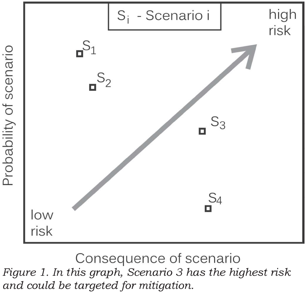
For decades, risk analysts for natural hazards have identified distinct scenarios (or potential events) which threaten something of value e.g. property or infrastructure. For each scenario, the probability of the natural event affecting the thing of value and the expected consequences are estimated (Kaplan and Garrick, 1981). Mitigation, if required, typically focuses on the scenarios with the highest risk (combination of probability and consequences). If the probability and consequences for each scenario can be quantified, the risk for the can be graphed as in Figure 1. If either the probability or consequence can only be ranked (not quantified), the scenarios are usually presented in a risk matrix (e.g. Ahrens, 2008, p. 22-24). The scenarios with the highest risk (or unacceptable risk) can be targeted for mitigation. This established approach to risk analysis has been used for long-return period avalanches that can affect property (e.g. Wilhelm, 1998). The same concept is also used informally by guides, forecasters and experienced recreationists, who often focus on one or two types of avalanches (scenarios) when assessing the risk on the terrain being considered for the current day.


For many years some Swiss guides and avalanche educators have proposed asking: “What is the main danger today?” On most days, it can be decided whether it is either a New Snow, and Old Snow, or a Wet Snow situation.


Once the situation is recognized, the mitigation strategy can be adapted (Wassermann and Wicky, 2003). Stephan Harvey has further formalized this approach, called it pattern recognition and added one more situation: Wind Driven Snow, when an increased avalanche danger often prevails (Harvey, 2008).


In parallel with the Swiss development of Avalanche Situations, at the 2004 ISSW in Jackson Hole, Roger Atkins proposed that the probability and consequences be assessed separately for different types of avalanches, e.g. wind slab, persistent slab, wet avalanche, so the decision makers could focus on the one or two scenarios (Avalanche Types) that posed the greatest risk. Some of his avalanche characteristics incorporated terrain, e.g. wind slabs near ridge tops.


Atkins’ concept was used by the Avalanche Danger Scale Project, which was a Canada-US part of the multi-agency project called Avalanche Decision Framework for Amateur Recreationists 2 (ADFAR2). Starting in 2005, the committee of mostly forecasters took a fresh look—actually fresh look after fresh look—at the forecasting process. When they finally had a consensus, the Avalanche Type was a key component of their conceptual forecasting model (Statham et al., 2010). Definitions for the different types of avalanches have been developed. These definitions were the basis for incorporating Avalanche Problems into Canadian avalanche bulletins (Klassen, 2010).

Most recently, Avalanche Type been used as the central theme in a field book for decision-making in avalanche terrain published by the Canadian Avalanche Centre (Klassen et al., 2010). The field book contains templates for recording the relevant observations and facilitates decisions when preparing for and travelling in avalanche terrain.


The concept of Avalanche Type has been and will continue to be applied at various scales. At the slope scale, experienced forecasters and guides can visualize certain types of potential avalanches on the terrain. At the regional scale, some avalanche forecast centres have started to use one, two, or occasionally three Avalanche Types in their public bulletins. Although there is as yet no consistent terminology (Table 1), the concept has caught on and is now used in various applications.


When updating the popular Swiss avalanche awareness brochure “Caution – Avalanches!” the idea of Avalanche Situations was merged with the reduction method with the classical 3x3 framework (Harvey et al., 2009). For each of the four Avalanche Situations, a number of key observations are proposed to help recreationists focus on the most important observations for the day (Table 2).


Early experience with this scheme suggests that on some days it is difficult to distinguish between new snow and wind driven snow. Also, the debate continues about whether to explicitly recommend digging when old snow is the dominant avalanche situation. On the other hand, the emphasis is not on digging when either new snow, wind driven snow or wet snow is the primary avalanche situation.


The relevant observations for each Avalanche Type in Table 2 are based on experience and an understanding of the processes that form the different types of potential avalanches. Haegeli and Atkins (2010) also present key observations from a survey of experienced avalanche professionals. For this study, we set out to use field data (independent of theory or experience) to identify some key observations when different types of avalanches were dominating the danger rating.


METHODS AND DATA
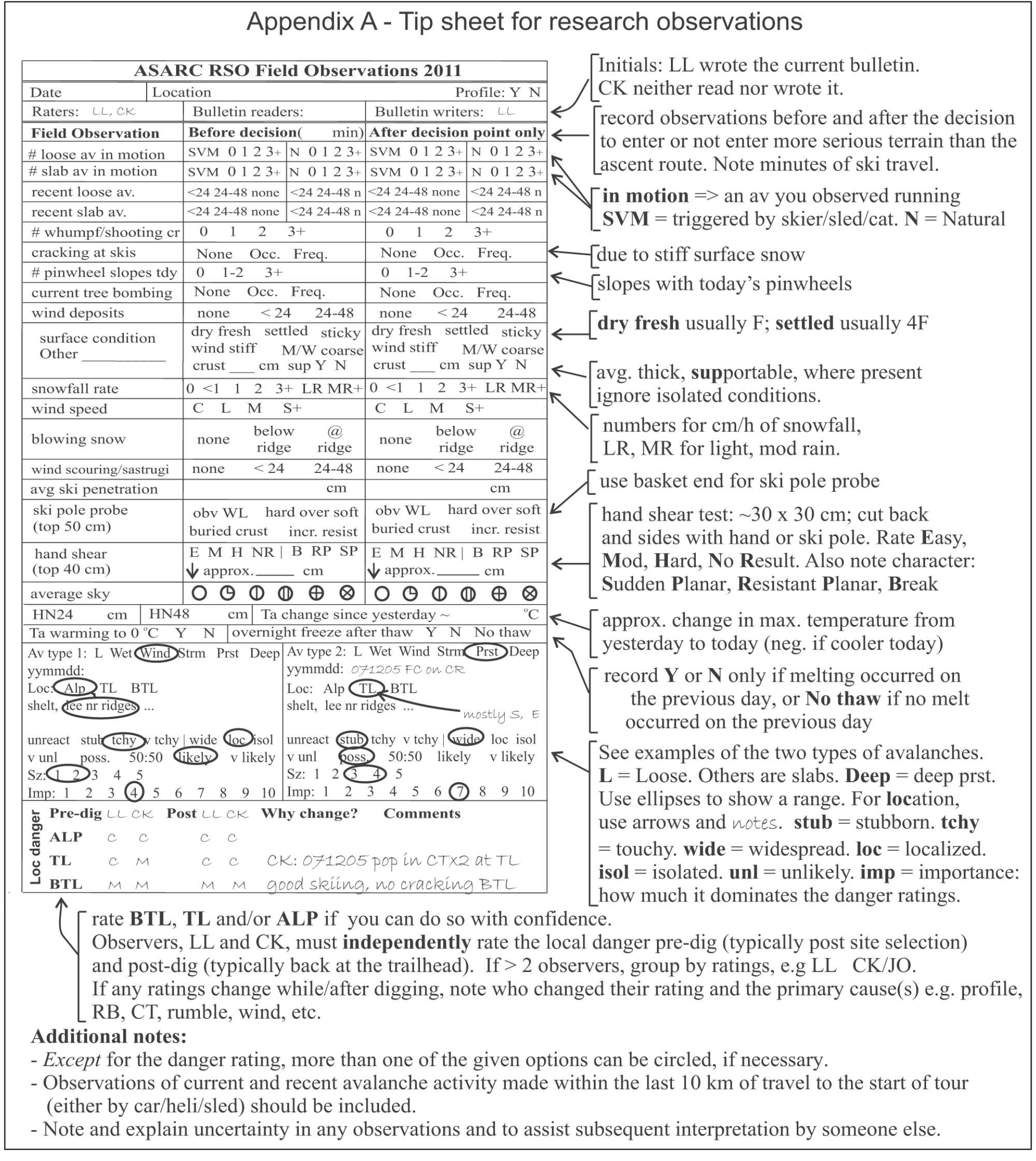
Since the winter of 2007, the Applied Snow and Avalanche Research group at the University of Calgary (ASARC) has been rating the local avalanche danger and making a standard set of over 20 observations (e.g. Jamieson and Haegeli, 2008; Appendix A). Starting in the winter of 2009, we began daily rating the top two Avalanche Types so we could assess which observations were “best” for the various types of expected avalanches. This paper summarizes the results from the winters of 2008-09 and 2009-10.


On most field days in the winters of 2008-09 and 2009-10, ASARC’s field teams in the Coast Range, Columbia Mountains and Rocky Mountains rated the local avalanche danger, made over 20 standard observations (Appendix A), and identified the two most important Avalanche Types (Table 1). For this study we used only the Avalanche Type with the greatest importance—based on its contribution to the danger rating. If the two avalanche types had equal importance (50:50), we used the one recorded as Avalanche Type 1.

Many of the observations were made before and after the decision point, i.e. when the team reached treeline. For each observation, e.g. blowing snow, we used the before or after observation that was more conducive to higher avalanche danger. So, if we observed blowing snow in the morning but not in the afternoon, we used the morning observation.


For most of the observation variables, the specific observation values could be ordered from the least associated with avalanching to the most. For example, the observations for blowing snow were ordered: none, at ridge, below ridge.

Appendix A shows that we rated the local danger for one, two or three elevation zones: below treeline, treeline and alpine. We used the treeline rating, except in four cases in which we did not rate the local avalanche danger at treeline, in which case we used the below treeline rating.

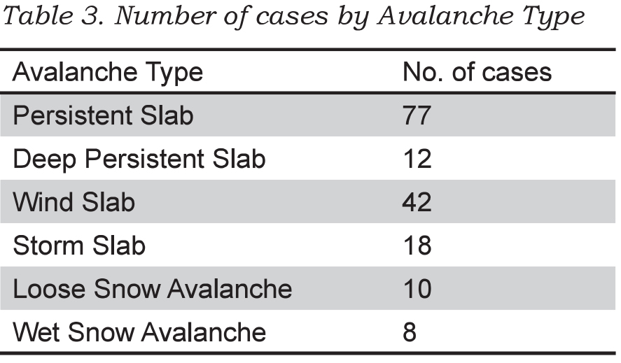
In a few cases in which the precipitation was rain, we treated the precipitation rate as missing. This resulted in the dataset shown in Table 3. Each case is a record of one field team travelling on touring skis in a specific area on a given day.


We excluded Loose Avalanche and Wet Avalanche types from the analysis since there were too few cases. Also because of limited cases, we combined Storm Slab with Wind Slab, and combined Deep Persistent Slab with Persistent Slab.


PRELIMINARY RESULTS
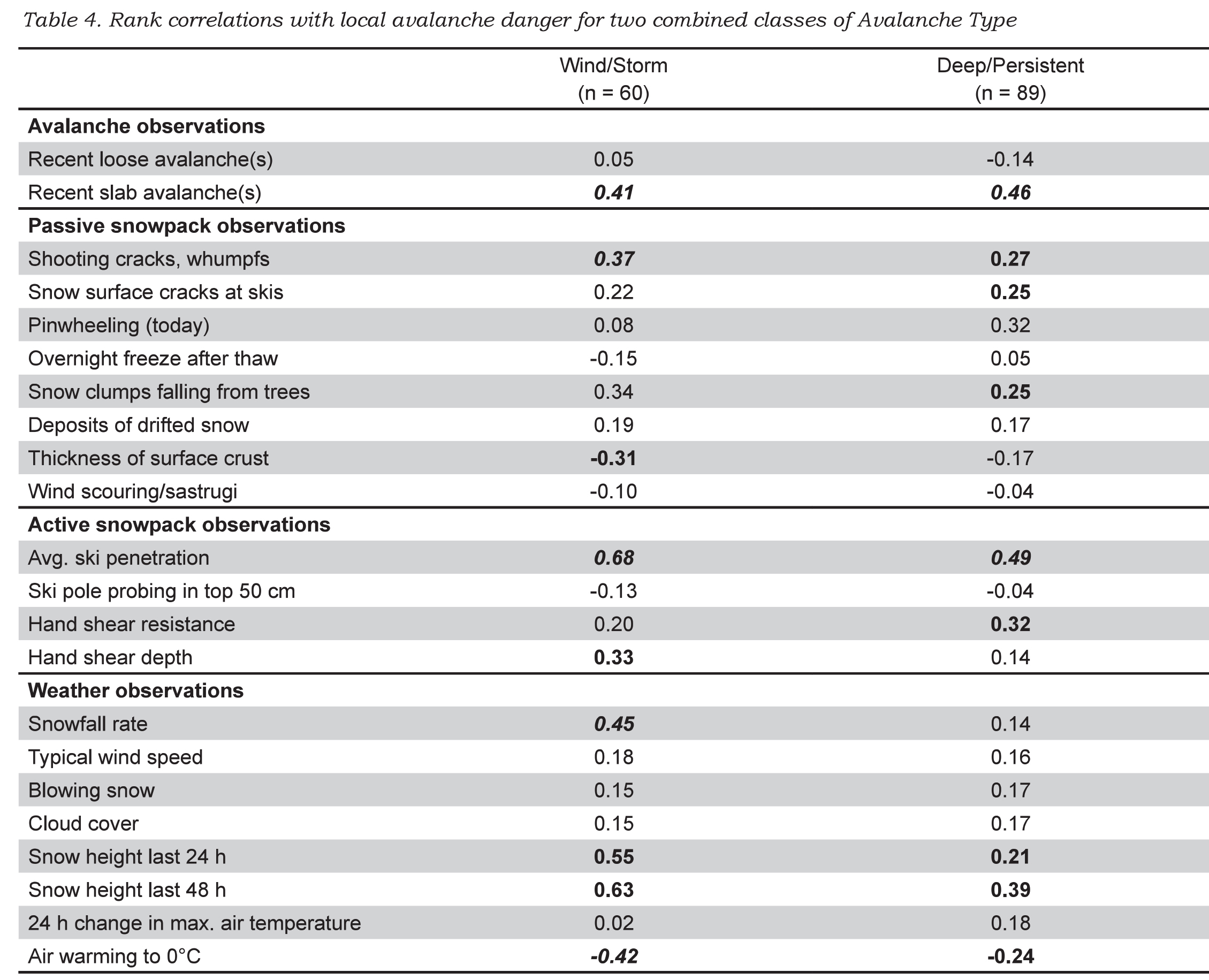
Spearman rank correlations between the local danger rating and the ordered observations are shown in Table 4. Correlations for which p < 0.05 are marked in bold. Correlations for which p < 0.01 are marked in bold italic.


Observations that correlated when either class of Avalanche Type was important?
When either Wind Slab/Storm Slab Avalanches or Deep/Persistent slab avalanches dominated the danger rating, the observations that correlated with the local avalanche danger were: slab avalanches, whumpfs/shooting cracks, clumps of snow falling off trees (tree bombs), deep ski penetration, snow height (snowfall) from in last 24/48 h, and air warming to 0°C (negative) (Table 4). The negative correlation prompted a second look at the data: when the air temperature reached 0°C (usually spring time), the avalanche danger was mostly Low or Moderate.


Observations that correlated when storm snow or wind slabs were important?
In addition to the observations mentioned in the previous paragraph, the snowfall rate, increased hand shear depth and absence of a surface melt-freeze crust correlated with the local avalanche danger when storm snow or wind slabs dominated the danger rating (Table 4). The key variables include the following observations of current or recent snowfall: snowfall rate, accumulated snowfall in the last 24/48 hours, as well as deep ski penetration.


Observations that correlated when deep/persistent slab avalanches were important?
In addition to the observations mentioned for both classes of Avalanche Types, low hand shear resistance, pinwheeling, and snow surface cracking at skis correlated with the local avalanche danger when Deep/Persistent Slab Avalanches dominated the local danger rating.


DISCUSSION
The observations proposed by the Swiss avalanche awareness brochure Caution – Avalanches! (Harvey et al., 2009) and the Canadian Avalanche Centre field book (Klassen et al., 2010) are supported by the correlations in Table 4. For a New Snow Avalanche Situation, recent slab avalanches and new snow amount correlated with the local avalanche danger. For an Old Snow Avalanche Situation, whumpfs correlated with the local avalanche danger. Some correlations, such as the one between pinwheeling and the local danger when Deep/Persistent Slabs are important, are difficult to explain and may not be significant in a larger, more balanced dataset.

For Deep/Persistent Slabs, fewer observations correlated with local danger than for Storm Snow and Wind Slab Avalanches, which is consistent with the greater forecasting challenge for persistent slabs. See also the limited relevant observations in Table 2 for the Old Snow Avalanche Situation.


Research often yields unexpected results. When ASARC’s morning stability evaluation was expanded to include identification of the one or two most important Avalanche Types, one of us (Jamieson) expected the usual response to increased paperwork. Instead, the field staff liked the focus that Avalanche Type provided to the morning safety meeting and has retained it. The Avalanche Type is just one part of the rethinking of the forecasting (Statham et al., 2010) that has become popular with ASARC’s field staff.


SUMMARY
Several regional forecast centres have adopted the concept of Avalanche Character/Type/Threat/Concern/Situation/Problem for use in their public bulletins. This concept is consistent with the scenarios in traditional risk analysis. Harvey (2008) has proposed specific observations for certain classes of Avalanche Situations. For this study, we analysed a dataset of 159 cases (locationdays) in which over 20 observations were made and the local avalanche danger was rated. When the dominant Avalanche Type was either Storm Avalanches or Wind Slabs, the observations that correlated (and were consistent with knowledge of avalanche formation) included recent slab avalanches, snowfall rate, snow clumps falling from trees (usually indicative of wind or warming), deep ski penetration and snow height from the last 24/48 hours. When the dominant Avalanche Type was either Deep Persistent or Persistent Slab, the observations that correlated (and made sense) included recent slab avalanches, whumpfs/shooting cracks, deep ski penetration and increased snow height from the last 24/48 hours.

Further field studies are planned. There are other observations that correlated in this study and may benefit from analysis of a larger dataset. However, any recommended observations should be consistent with the current understanding of the processes that form the different types of avalanches.


ACKNOWLEDGEMENTS
For the careful field work we are grateful to Cam Campbell, Spencer Krkosky, Deanna Andersen, Lydia Marmont, Peter Marshall, Chris Geisler, Ali Haeri, Cameron Ross, Thomas Exner, Mark Kolasinski, Katherine Johnston, Cora Shea, Mike Smith, Dave Tracz and Jordan Stiefvater. Thanks also to Mike Smith for proofreading, to Cameron Ross for checking the data and Dave Gauthier for checking the analysis.


For logistical support for the field studies we thank Mike Wiegele Helicopter Skiing, BC Ministry of Transportation and Infrastructure, BC Ministry of Parks, Parks Canada, the Canadian Avalanche Centre, as well as the Avalanche Control Section of Glacier National Park.


For financial support for the field studies and the first author’s time, we thank the Natural Sciences and Engineering Research Council of Canada, HeliCat Canada, the Canadian Avalanche Association, Mike Wiegele Helicopter Skiing, Teck Mining Company, Canada West Ski Areas Association, the Association of Canadian Mountain Guides, Backcountry Lodges of British Columbia, and the Canadian Ski Guides Association.

REFERENCES
Ahrens, T. 2008. Risk Analysis. John Wiley & Sons, Chichester, England.

Atkins, R. 2004. An avalanche characterization checklist for backcountry travel decisions. Proceedings of the 2004 International Snow Science Workshop in Jackson Hole, Wyoming, USA, 462-468.


Haegeli, P., Atkins, R. 2010. Exploring the ‘It depends’ – How do mountain guides assess avalanche situations? In Osterhuber,

R. and Ferrari, M. (eds.), Proceedings of the 2010 International Snow Science Workshop in Squaw Valley, California, USA, 130-132.

Harvey, S. 2008. Mustererkennung in der Lawinenkunde. In: I. Kroath (Editor), Sicherheit im Bergland. Oesterreichisches Kuratorium für Alpine Sicherheit, Innsbruck, Austria, pp. 88-94.

Harvey, S., Schweizer, J., Rhyner, H., Nigg, P., Hasler, B. 2009. Caution - Avalanches! 6th edition. Avalanche Prevention in Snow Sports, Core team of instructors, Davos, Switzerland.

Jamieson, B., Haegeli, P. 2008. Can field observations be combined systematically with the regional danger rating to estimate the local avalanche danger? Proceedings of the 2008 International Snow Science Workshop in Whistler, BC, 228-237.


Kaplan, S., Garrick, B.J. 1981. On the quantitative definition of risk. Risk Analysis 1(1), 11-21.


Klassen. K. 2010. The Avalanche Hazard Assessment Web-tool – A structured approach to public avalanche forecasting. Presentation at the Spring Conference of the Canadian Avalanche Association, 6-7 May 2010.

Haegeli, P., Atkins, R., Klassen, K. 2010. Decision Making in Avalanche Terrain. Canadian Avalanche Centre, Revelstoke, BC, 62 pp.


Statham, G., Haegeli, P., Birkeland, K., Greene, E., Israelson, C., Tremper, B., Stethem, C., McMahon, B., White, B., Kelly, J. 2010. In Osterhuber, R. and Ferrari, M. (eds.), A conceptual model of avalanche hazard. Proceedings of the 2010 International Snow Science Workshop in Squaw Valley, California, USA, 686.


Wassermann, E., Wicky, E. 2003. Lawinen und Risikomanagement. Edition Filidor, Reichenbach, Switzerland, 60 pp.


Wilhelm, C. 1998. Quantitative risk analysis for evaluation of avalanche protection projects. In Hestnes, E., ed. Proceedings of the Anniversary Conference 25 Years of Snow Avalanche Research, Voss, 12-16 May 1998. Oslo, Norwegian Geotechnical Institute, Publication 203, 288-293

Tags:  avalanche journal  avalanche observations  avalanche research  avalanche types  snowpack tests 

PermalinkComments (0)
 
Box 2759, 110 MacKenzie Ave
Revelstoke, BC Canada, V0E 2S0
Find us
Tel 250-837-2435
Fax 866-366-2094
Contact us
Membership Management Software Powered by YourMembership  ::  Legal