From volume 96, spring 2011
By Bruce Jamieson, Dept. of Civil Engineering, Dept. of Geoscience, University of Calgary, Calgary AB, Canada
Jürg Schweizer, WSL Institute for Snow and Avalanche Research SLF, Davos, Switzerland
Grant Statham, Parks Canada Agency, Banff AB, Canada
Pascal Haegeli, Avisualanche Consulting and Simon Fraser University, Vancouver BC, Canada
ABSTRACT
At the 2004 ISSW, Roger Atkins proposed that—early in the terrain selection process—backcountry travellers could identify which types of avalanches were likely, e.g. wind slab, persistent slab, wet avalanche. These avalanche types are analogous to a set of scenarios in traditional risk analysis. Variations on Atkins’ approach have been incorporated into some public bulletins. The types of avalanches that dominate the danger ratings are called Avalanche Types/Characters/Threats/Concerns/Situations/Problems by different groups. The latest Swiss brochure for recreation in avalanche terrain suggests different observations for the four different types of avalanche situations. To help determine which observations are best for which types of avalanches, a field study was conducted in the winters of 2008-09 and 2009-10 in the Coast Mountains, Columbia Mountains, and Rocky Mountains of western Canada. On each field day, an experienced field team rated the local avalanche danger, identified two dominant avalanche types and observed a standard set of over 20 quick field observations. The quick observations included avalanches, wind transported snow, snowfall, etc. For correlation analysis, we focussed on two distinct classes of avalanche types: 1) persistent slabs, and 2) wind slabs combined with storm slabs. While some observations correlated with the local danger when either class of avalanches dominated the danger rating, other observations correlated best when only one of these two classes dominated the local danger rating. These results may help bulletin writers recommend that recreationists focus on certain local observations for better informed decisions.
INTRODUCTION
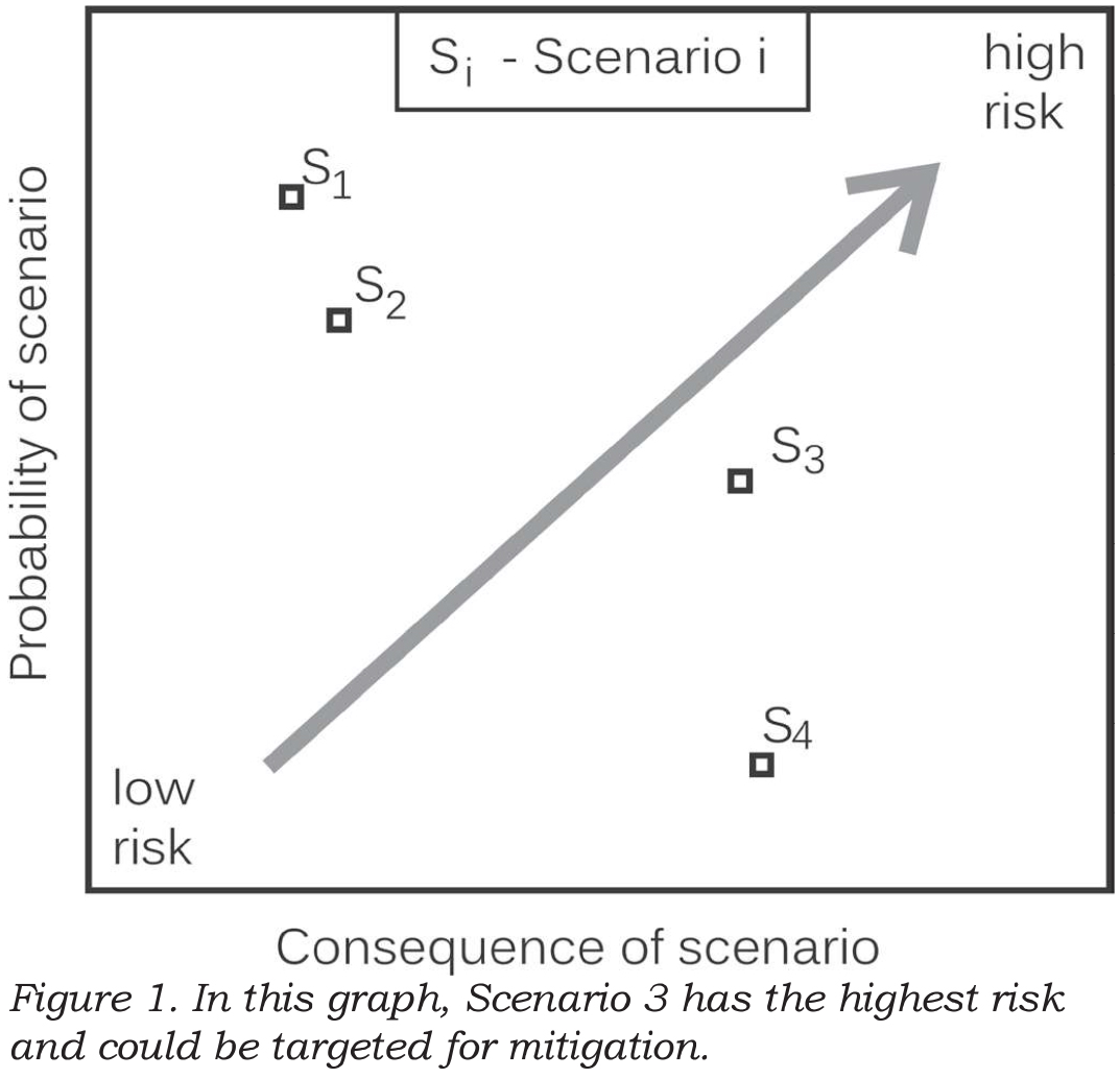
For decades, risk analysts for natural hazards have identified distinct scenarios (or potential events) which threaten something of value e.g. property or infrastructure. For each scenario, the probability of the natural event affecting the thing of value and the expected consequences are estimated (Kaplan and Garrick, 1981). Mitigation, if required, typically focuses on the scenarios with the highest risk (combination of probability and consequences). If the probability and consequences for each scenario can be quantified, the risk for the can be graphed as in Figure 1. If either the probability or consequence can only be ranked (not quantified), the scenarios are usually presented in a risk matrix (e.g. Ahrens, 2008, p. 22-24). The scenarios with the highest risk (or unacceptable risk) can be targeted for mitigation. This established approach to risk analysis has been used for long-return period avalanches that can affect property (e.g. Wilhelm, 1998). The same concept is also used informally by guides, forecasters and experienced recreationists, who often focus on one or two types of avalanches (scenarios) when assessing the risk on the terrain being considered for the current day.
For many years some Swiss guides and avalanche educators have proposed asking: “What is the main danger today?” On most days, it can be decided whether it is either a New Snow, and Old Snow, or a Wet Snow situation.

Once the situation is recognized, the mitigation strategy can be adapted (Wassermann and Wicky, 2003). Stephan Harvey has further formalized this approach, called it pattern recognition and added one more situation: Wind Driven Snow, when an increased avalanche danger often prevails (Harvey, 2008).
In parallel with the Swiss development of Avalanche Situations, at the 2004 ISSW in Jackson Hole, Roger Atkins proposed that the probability and consequences be assessed separately for different types of avalanches, e.g. wind slab, persistent slab, wet avalanche, so the decision makers could focus on the one or two scenarios (Avalanche Types) that posed the greatest risk. Some of his avalanche characteristics incorporated terrain, e.g. wind slabs near ridge tops.
Atkins’ concept was used by the Avalanche Danger Scale Project, which was a Canada-US part of the multi-agency project called Avalanche Decision Framework for Amateur Recreationists 2 (ADFAR2). Starting in 2005, the committee of mostly forecasters took a fresh look—actually fresh look after fresh look—at the forecasting process. When they finally had a consensus, the Avalanche Type was a key component of their conceptual forecasting model (Statham et al., 2010). Definitions for the different types of avalanches have been developed. These definitions were the basis for incorporating Avalanche Problems into Canadian avalanche bulletins (Klassen, 2010).
Most recently, Avalanche Type been used as the central theme in a field book for decision-making in avalanche terrain published by the Canadian Avalanche Centre (Klassen et al., 2010). The field book contains templates for recording the relevant observations and facilitates decisions when preparing for and travelling in avalanche terrain.
The concept of Avalanche Type has been and will continue to be applied at various scales. At the slope scale, experienced forecasters and guides can visualize certain types of potential avalanches on the terrain. At the regional scale, some avalanche forecast centres have started to use one, two, or occasionally three Avalanche Types in their public bulletins. Although there is as yet no consistent terminology (Table 1), the concept has caught on and is now used in various applications.
When updating the popular Swiss avalanche awareness brochure “Caution – Avalanches!” the idea of Avalanche Situations was merged with the reduction method with the classical 3x3 framework (Harvey et al., 2009). For each of the four Avalanche Situations, a number of key observations are proposed to help recreationists focus on the most important observations for the day (Table 2).
Early experience with this scheme suggests that on some days it is difficult to distinguish between new snow and wind driven snow. Also, the debate continues about whether to explicitly recommend digging when old snow is the dominant avalanche situation. On the other hand, the emphasis is not on digging when either new snow, wind driven snow or wet snow is the primary avalanche situation.
The relevant observations for each Avalanche Type in Table 2 are based on experience and an understanding of the processes that form the different types of potential avalanches. Haegeli and Atkins (2010) also present key observations from a survey of experienced avalanche professionals. For this study, we set out to use field data (independent of theory or experience) to identify some key observations when different types of avalanches were dominating the danger rating.

METHODS AND DATA
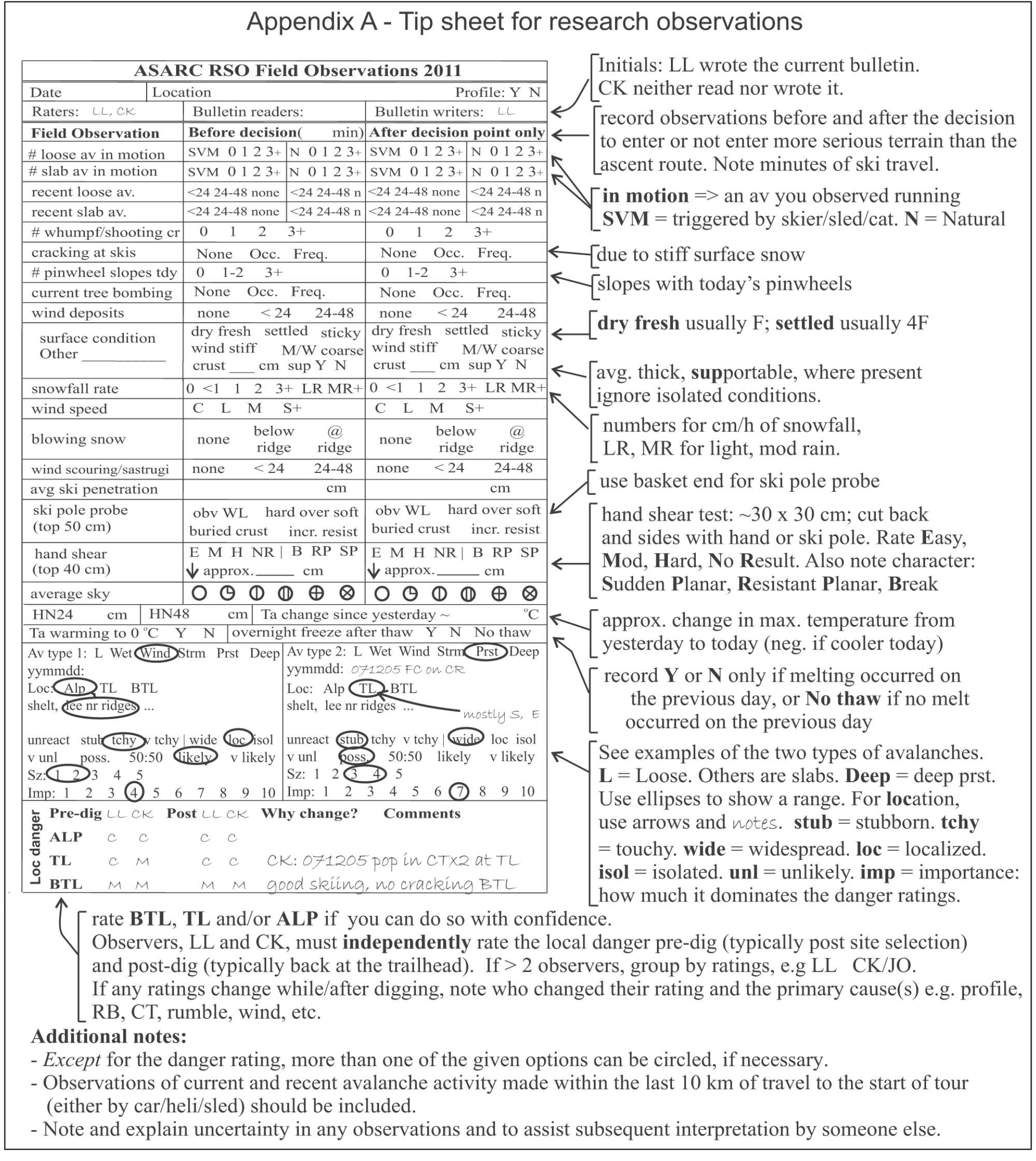
Since the winter of 2007, the Applied Snow and Avalanche Research group at the University of Calgary (ASARC) has been rating the local avalanche danger and making a standard set of over 20 observations (e.g. Jamieson and Haegeli, 2008; Appendix A). Starting in the winter of 2009, we began daily rating the top two Avalanche Types so we could assess which observations were “best” for the various types of expected avalanches. This paper summarizes the results from the winters of 2008-09 and 2009-10.
On most field days in the winters of 2008-09 and 2009-10, ASARC’s field teams in the Coast Range, Columbia Mountains and Rocky Mountains rated the local avalanche danger, made over 20 standard observations (Appendix A), and identified the two most important Avalanche Types (Table 1). For this study we used only the Avalanche Type with the greatest importance—based on its contribution to the danger rating. If the two avalanche types had equal importance (50:50), we used the one recorded as Avalanche Type 1.
Many of the observations were made before and after the decision point, i.e. when the team reached treeline. For each observation, e.g. blowing snow, we used the before or after observation that was more conducive to higher avalanche danger. So, if we observed blowing snow in the morning but not in the afternoon, we used the morning observation.
For most of the observation variables, the specific observation values could be ordered from the least associated with avalanching to the most. For example, the observations for blowing snow were ordered: none, at ridge, below ridge.
Appendix A shows that we rated the local danger for one, two or three elevation zones: below treeline, treeline and alpine. We used the treeline rating, except in four cases in which we did not rate the local avalanche danger at treeline, in which case we used the below treeline rating.
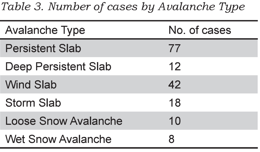
In a few cases in which the precipitation was rain, we treated the precipitation rate as missing. This resulted in the dataset shown in Table 3. Each case is a record of one field team travelling on touring skis in a specific area on a given day.
We excluded Loose Avalanche and Wet Avalanche types from the analysis since there were too few cases. Also because of limited cases, we combined Storm Slab with Wind Slab, and combined Deep Persistent Slab with Persistent Slab.

PRELIMINARY RESULTS
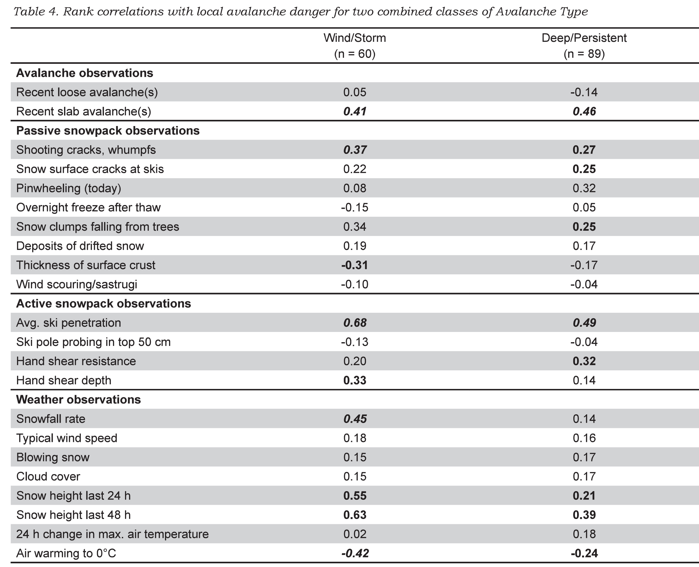
Spearman rank correlations between the local danger rating and the ordered observations are shown in Table 4. Correlations for which p < 0.05 are marked in bold. Correlations for which p < 0.01 are marked in bold italic.
Observations that correlated when either class of Avalanche Type was important?
When either Wind Slab/Storm Slab Avalanches or Deep/Persistent slab avalanches dominated the danger rating, the observations that correlated with the local avalanche danger were: slab avalanches, whumpfs/shooting cracks, clumps of snow falling off trees (tree bombs), deep ski penetration, snow height (snowfall) from in last 24/48 h, and air warming to 0°C (negative) (Table 4). The negative correlation prompted a second look at the data: when the air temperature reached 0°C (usually spring time), the avalanche danger was mostly Low or Moderate.
Observations that correlated when storm snow or wind slabs were important?
In addition to the observations mentioned in the previous paragraph, the snowfall rate, increased hand shear depth and absence of a surface melt-freeze crust correlated with the local avalanche danger when storm snow or wind slabs dominated the danger rating (Table 4). The key variables include the following observations of current or recent snowfall: snowfall rate, accumulated snowfall in the last 24/48 hours, as well as deep ski penetration.
Observations that correlated when deep/persistent slab avalanches were important?
In addition to the observations mentioned for both classes of Avalanche Types, low hand shear resistance, pinwheeling, and snow surface cracking at skis correlated with the local avalanche danger when Deep/Persistent Slab Avalanches dominated the local danger rating.
DISCUSSION
The observations proposed by the Swiss avalanche awareness brochure Caution – Avalanches! (Harvey et al., 2009) and the Canadian Avalanche Centre field book (Klassen et al., 2010) are supported by the correlations in Table 4. For a New Snow Avalanche Situation, recent slab avalanches and new snow amount correlated with the local avalanche danger. For an Old Snow Avalanche Situation, whumpfs correlated with the local avalanche danger. Some correlations, such as the one between pinwheeling and the local danger when Deep/Persistent Slabs are important, are difficult to explain and may not be significant in a larger, more balanced dataset.
For Deep/Persistent Slabs, fewer observations correlated with local danger than for Storm Snow and Wind Slab Avalanches, which is consistent with the greater forecasting challenge for persistent slabs. See also the limited relevant observations in Table 2 for the Old Snow Avalanche Situation.
Research often yields unexpected results. When ASARC’s morning stability evaluation was expanded to include identification of the one or two most important Avalanche Types, one of us (Jamieson) expected the usual response to increased paperwork. Instead, the field staff liked the focus that Avalanche Type provided to the morning safety meeting and has retained it. The Avalanche Type is just one part of the rethinking of the forecasting (Statham et al., 2010) that has become popular with ASARC’s field staff.

SUMMARY
Several regional forecast centres have adopted the concept of Avalanche Character/Type/Threat/Concern/Situation/Problem for use in their public bulletins. This concept is consistent with the scenarios in traditional risk analysis. Harvey (2008) has proposed specific observations for certain classes of Avalanche Situations. For this study, we analysed a dataset of 159 cases (locationdays) in which over 20 observations were made and the local avalanche danger was rated. When the dominant Avalanche Type was either Storm Avalanches or Wind Slabs, the observations that correlated (and were consistent with knowledge of avalanche formation) included recent slab avalanches, snowfall rate, snow clumps falling from trees (usually indicative of wind or warming), deep ski penetration and snow height from the last 24/48 hours. When the dominant Avalanche Type was either Deep Persistent or Persistent Slab, the observations that correlated (and made sense) included recent slab avalanches, whumpfs/shooting cracks, deep ski penetration and increased snow height from the last 24/48 hours.
Further field studies are planned. There are other observations that correlated in this study and may benefit from analysis of a larger dataset. However, any recommended observations should be consistent with the current understanding of the processes that form the different types of avalanches.

ACKNOWLEDGEMENTS
For the careful field work we are grateful to Cam Campbell, Spencer Krkosky, Deanna Andersen, Lydia Marmont, Peter Marshall, Chris Geisler, Ali Haeri, Cameron Ross, Thomas Exner, Mark Kolasinski, Katherine Johnston, Cora Shea, Mike Smith, Dave Tracz and Jordan Stiefvater. Thanks also to Mike Smith for proofreading, to Cameron Ross for checking the data and Dave Gauthier for checking the analysis.
For logistical support for the field studies we thank Mike Wiegele Helicopter Skiing, BC Ministry of Transportation and Infrastructure, BC Ministry of Parks, Parks Canada, the Canadian Avalanche Centre, as well as the Avalanche Control Section of Glacier National Park.
For financial support for the field studies and the first author’s time, we thank the Natural Sciences and Engineering Research Council of Canada, HeliCat Canada, the Canadian Avalanche Association, Mike Wiegele Helicopter Skiing, Teck Mining Company, Canada West Ski Areas Association, the Association of Canadian Mountain Guides, Backcountry Lodges of British Columbia, and the Canadian Ski Guides Association.
REFERENCES
Ahrens, T. 2008. Risk Analysis. John Wiley & Sons, Chichester, England.
Atkins, R. 2004. An avalanche characterization checklist for backcountry travel decisions. Proceedings of the 2004 International Snow Science Workshop in Jackson Hole, Wyoming, USA, 462-468.
Haegeli, P., Atkins, R. 2010. Exploring the ‘It depends’ – How do mountain guides assess avalanche situations? In Osterhuber,
R. and Ferrari, M. (eds.), Proceedings of the 2010 International Snow Science Workshop in Squaw Valley, California, USA, 130-132.
Harvey, S. 2008. Mustererkennung in der Lawinenkunde. In: I. Kroath (Editor), Sicherheit im Bergland. Oesterreichisches Kuratorium für Alpine Sicherheit, Innsbruck, Austria, pp. 88-94.
Harvey, S., Schweizer, J., Rhyner, H., Nigg, P., Hasler, B. 2009. Caution - Avalanches! 6th edition. Avalanche Prevention in Snow Sports, Core team of instructors, Davos, Switzerland.
Jamieson, B., Haegeli, P. 2008. Can field observations be combined systematically with the regional danger rating to estimate the local avalanche danger? Proceedings of the 2008 International Snow Science Workshop in Whistler, BC, 228-237.
Kaplan, S., Garrick, B.J. 1981. On the quantitative definition of risk. Risk Analysis 1(1), 11-21.
Klassen. K. 2010. The Avalanche Hazard Assessment Web-tool – A structured approach to public avalanche forecasting. Presentation at the Spring Conference of the Canadian Avalanche Association, 6-7 May 2010.
Haegeli, P., Atkins, R., Klassen, K. 2010. Decision Making in Avalanche Terrain. Canadian Avalanche Centre, Revelstoke, BC, 62 pp.
Statham, G., Haegeli, P., Birkeland, K., Greene, E., Israelson, C., Tremper, B., Stethem, C., McMahon, B., White, B., Kelly, J. 2010. In Osterhuber, R. and Ferrari, M. (eds.), A conceptual model of avalanche hazard. Proceedings of the 2010 International Snow Science Workshop in Squaw Valley, California, USA, 686.
Wassermann, E., Wicky, E. 2003. Lawinen und Risikomanagement. Edition Filidor, Reichenbach, Switzerland, 60 pp.
Wilhelm, C. 1998. Quantitative risk analysis for evaluation of avalanche protection projects. In Hestnes, E., ed. Proceedings of the Anniversary Conference 25 Years of Snow Avalanche Research, Voss, 12-16 May 1998. Oslo, Norwegian Geotechnical Institute, Publication 203, 288-293


