Avalanche Journal Blog
Blog Home All Blogs
This is the blog of the Avalanche Journal. Here you will be able to read articles that appeared in past editions of the Avalanche Journal. Our digital archives currently go back to spring 2005 (volume 72) and we will be posting one article each week from a select issue.


Search all posts for:   


Top tags: avalanche journal  avalanche forecasting  snowpack tests  avalanche  avalanche control  avalanche education  avalanche research  snow science  avalanche incident  bruce jamieson  case study  companion rescue  ice climbing  kootenay pass  laura maguire  ministry of transportation  MOTI  roger atkins  strategic mindset  wren mcelroy  airbag  applied snow and avalanche research centre  asarc  aspen  AST 1  ates  atmospheric river  avalanche canada  avalanche detection  avalanche fences 

Avalanche Education at Kootenay Pass

Posted By Alex Cooper, Canadian Avalanche Association, March 18, 2020

From volume 100, spring 2012

Story and photo by Wren McElroy


“NUMEROUS AND LARGE AVALANCHES IN THE WINTER OF 1971-72 STIMULATED A GROWING INTEREST IN AVALANCHE SAFETY EDUCATION.” – PETER SCHEARER


DID BEING BORN IN 1972 HELP SHAPE MY PASSION FOR AVALANCHE EDUCATION?


OVER THE PAST three years, that passion has helped bring John Tweedy’s vision of using the old highway crew camp at Kootenay Pass as a base for avalanche education to fruition. The combination of easy access to terrain and exposure to an active MOT avalanche control program make the base camp an ideal location for learning. Tweedy was the BC Ministry of Transportation’s first avalanche technician at Kootenay Pass, starting in 1980 and retiring in 2010.


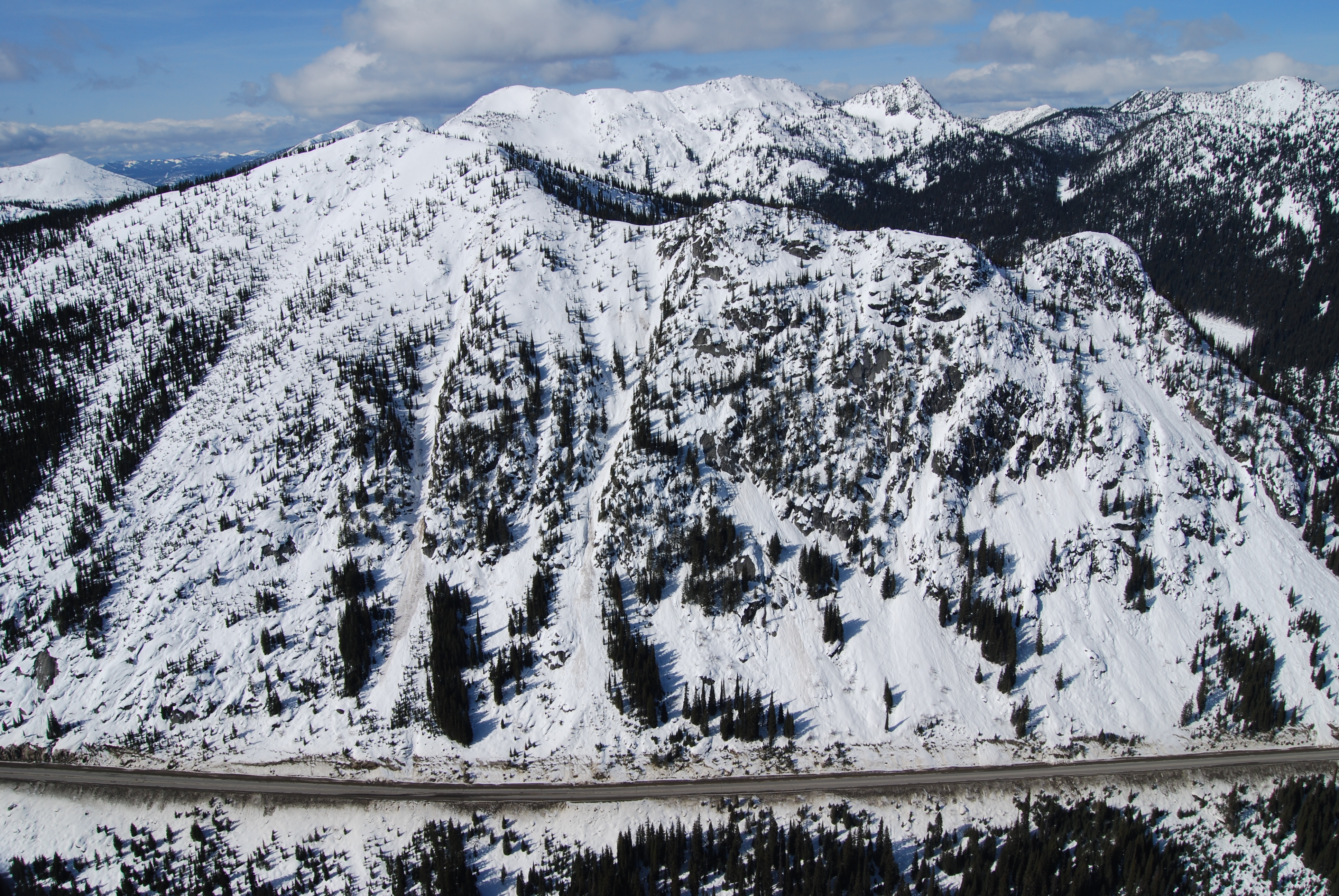
Construction of the highway between Salmo and Creston was begun in the late 1950s; it was opened with ceremony in August 1964. The highway ran right through many kilometres of avalanche paths on both the east and west side of Kootenay Pass. Crews were surprised by the amount of snow on the south facing slopes when they resumed work in the spring—avalanche debris stopped the plow truck drivers from reaching the pass. The original camp for the maintenance crew, equipment operators, plow truck drivers and avalanche technicians was set up in the early 1970s at 1,775m. During a particularly heavy storm cycle, assistant avalanche technician Dave Smith’s truck was buried in the yard, and then run over by a plow. He hitchhiked home.


Early Kootenay Pass professional avalanche courses started in 1979 and ran until 1991, based out of a Creston hotel. A nearby Greek restaurant even created an official training school libation called “the avalanche.” Courses offered included the RTAM Level 1 and Level 2 (Resource Transportation Avalanche Management) and CAA Avalanche Operations Level 1 and 2. During 1981-82, four fully supported manual weather stations were put in place, provided by MOT for the Creston-based courses.


Eventually, the daily 120km drive from Creston proved to be too much and courses at the pass began to wane. Furthermore, the highway maintenance was transferred to a contractor who did not maintain the course snow study plots at the Kootenay Pass summit. Another attempt to hold a Level 1 course at Kootenay Pass was made in the late 1990s, and John Buffery and Marc Deschênes drove from Nelson with students. Days at Kootenay Pass were interspersed with trips to Whitewater, but it was still too much driving.


In 1992, a new building named the Bunkhouse was built, which was a welcome relief from the ATCO trailers that populated the pass. MOT and the road and bridge maintenance contractor manned the building until 2005. When the maintenance contractor started plowing out of Creston, the need for a manned camp at the pass dissolved.


Laura Adams, a CAA Professional Member teaching the Renewable Resource Program at Selkirk College, signed a memorandum with Parks in 2002 to able to teach in Stagleap Provincial Park, but did not use the building. A number of courses for that program were taught up there. I taught a three-day winter camping/RAC course there in 2003 with Laura’s successor Keyes Lessard. Other Selkirk College AST courses were taught there throughout the 2000s, including a course Keyes and I taught for the Department of National Defense. I used the building to teach an all-women AST 2 course I in 2005, and benefitted from a presentation and mock avalanche scenario by Ministry of Transportation. In 2006 and 2008, the RCMP and the Mountain National Park Dog Handlers used the Bunkhouse for Dog Handler Validation courses, which did not seem to impact the day-to-day operations of the avalanche program.


At that time, BC Parks weighed in on the building’s usage. They did not want to see a mountain hostel at the pass; however, they were very supportive of the educational opportunities that could be offered up there. Two BC Parks staff, Dave Heagy, Senior Parks Ranger and Jeff Volp, Area Supervisor, taught AST 1 courses up at the pass for the Ministry of Environment in 2010 and 2011. Participants included Park Rangers and Senior Rangers, Area Supervisors, Conservation Officers, and other Ministry of Environment Staff. All the participants stayed at the Bunkhouse and utilized the classroom, kitchen and living facilities.


In the fall of 2009, John Tweedy and I spoke of starting the CAA Avalanche Operations Level 1 courses again up at the Pass. We agreed on the benefits for the students, instructors and the ITP program to run the courses there. Ian Tomm asked for a proposal. John laughed at the simplicity: the facility is free, the travel is free, it’s all here, he said; bring the students, instructors and a cook and you are good to go. The biggest challenge of a hut-based course is the logistics of the helicopter transport, but at Kootenay Pass, everyone drives there and then they stay. Students and instructors have full days without worrying about driving times, meal preparation or cold students sleeping in the back of trucks. Three years in a row, I missed the first day of teaching a CAA Level 1 course at Kokanee Glacier Cabin because of short December days and difficult weather. At Kootenay Pass, that is not an issue.


In January 2010, students stayed in the Bunkhouse as Course Leader, Mike Rubenstein and I taught the first CAA Level 1. The week was a resounding success, with support from the MOT crew, fantastic catering and good weather. Three Level 1 courses have been run in 2011 and 2012, with positive reviews from all parties involved.


The Bunkhouse can accommodate 13 students, two instructors and a cook, with private rooms and shared washroom facilities. There is a separate kitchen, classroom and inside storage for skis and gear. The MOT avalanche staff maintains a residence as well. A great benefit is the close involvement with the MOT Highways avalanche control program.


A short walk from the building, the Avalanche Technicians have enlarged their existing weather plot; the twice daily weather observations are easy to get to and relevant. Even as we move into the digital age of weather stations, having a professional, manual weather station for students to use adjacent to the Highways weather station certainly enhances the hands-on learning. Anyone can read a digital screen, but to walk out in the cold, dark air of the early morning and read a maximum and minimum thermometer is better for tactile learners.


The elevation of 1,775m is a great starting place for ski tours, and each day progresses further into the terrain. With short travel times, groups are able to get to their study areas, look at terrain and have time to dig their profiles. Some days we were able to travel and dig test profiles on two different aspects. Mid-week we travel to Whitewater Ski Resort, an hour’s drive to the west, where students see another active avalanche program. This provides good linking to lessons—by that point, the students have started using the daily hazard evaluations and drafting snow profiles and they get the opportunity to see all of those skills put into practice. Also, with the easy-access backcountry a short tour from the resort, students are quickly exposed to a different scope of terrain. Whitewater provides one-ride passes for the students and instructors in exchange for ITP credits for Whitewater staff.


Later in the week, Tweedy successor Robb Andersen presents on the MOT avalanche control program. Robb also demonstrates an avalanche rescue scenario with his dog Kilo. A unique benefit to Kootenay Pass is witnessing the Gaz.ex avalanche control in progress. This year we arrived on Sunday, January 29 as a significant storm cycle was occurring. Robb closed the highway at 02:30 in a high hazard. He woke Dave Smith and me up at 05:00 to let us know they were going to do a shoot. Students were in a safe zone on the highway by 05:30 to experience how avalanche hazard is managed and mitigated on the highest all-weather mountain pass in Canada. We could see the flash of the Gaz.ex and hear the rumble of the size 3 and 3.5 avalanches as they buried the highway. Robb’s incredible video footage of control work allowed the students to see the magnitude of what they could hear. The highway remained closed that day until 2:30pm, but the class was secure in the Bunkhouse learning about the nature and formation of avalanches.


Many stakeholders are involved with the operation of the Bunkhouse at Kootenay Pass. BC Parks owns the land, MOT built and owns the building, and the Highways Road and Bridge Maintenance Contractor is responsible for the upkeep of the building. Infrastructure upgrades including potable water, plumbing upgrades and reducing the carbon footprint are in the plans for the coming summer season to allow for continued operation of courses.


Using the Bunkhouse for educational courses is a win-win situation for course participants and the various agencies that take advantage of having their courses at Kootenay Pass.


Tags:  avalanche education  industry training program  kootenay pass  wren mcelroy 

PermalinkComments (0)
 

Avalanche Prediction Modelling

Posted By Alex Cooper, Canadian Avalanche Association, January 22, 2020

From vol. 106, spring 2014 

By Paul Cordy


DEPOSIT FROM PATH 19.3 IN KOOTENAY PASS. A SIZE 3 AVALANCHE TRIGGERED BY HELI BOMBING // MOTI


IN THE WORLD OF BIG DATA we have become accustomed to interacting with computer models. The search for good snow inevitably begins by consulting the ensemble weather forecast (the consensus weather prediction of five different detailed models of the atmosphere), just as most searches for knowledge these days begin by consulting Google (a complex and dynamic model of the relevance of digital information). So one might expect that any day now Big Data will begin to spread its tentacles into the world of avalanche safety. But are there particular challenges to using computer models for avalanche prediction? Not the least of these may be thecomplexity of geographic and human factors leading to avalanche formation, and also the scarcity of reliable and continuous information about conditions in the start zones.


So how far have avalanche prediction models come, and how might they benefit organizations and individuals? Will they ever be good enough to rely on in Canada? The British Columbia Ministry of Transportation and Infrastructure (MOTI) has a long history of taking the lead in creating digital tools for avalanche practitioners. These efforts have led to the development of one tool that we know and use already: SnowPro. A lesser-known innovation of the MOTI is the computer-based avalanche forecasting system which began more than 15 years ago in Kootenay Pass. Ted Wieck, former information systems manager for the MOTI avalanche and weather branch, spent over a decade developing the MOTI’s first digital highway, weather, and avalanche database. In the beginning, this meant considerable amounts of tedious data entry for technicians, who would have rather spent more time in the hills and on the road. Ted wanted to make all that data useful to the people who were assiduously collecting it for him, and so he became a fervent supporter of computer-based avalanche prediction.


In the mid-nineties, Dr. David McClung and John Tweedy developed and tested software that used manual weather observations (input by the user, of course) to predict the probability of avalanche activity that day. The prediction was based on a statistical model that was created using historical weather data and avalanche occurrence records from the previous ten seasons at Kootenay Pass. As in all computer models (including Google’s search engine), historic data is used to train the model, or in the case of MOTI, determine the relative importance of various weather variables and how to combine them in a way that computes accurate predictions of avalanches.


This is not too dissimilar to the way that we humans learn. Our experience is combined with training to create mental models of how weather creates avalanches. Often we will compare current weather or snowpack structure with previous seasons’ observations to refine our decisions. The original Kootenay Pass model also retrieved the ten most similar instances of weather and presented the data to the human forecaster to further aid in decision making. In the end, both model approaches were 70-80% accurate. Early in the 2000s, James Floyer proved that similar models could be trained on Bear Pass datasets with similar results.


A CROWN ON PATH 19.8, KOOTENAY PASS // MOTI


As a Masters student with McClung at the University of British Columbia, my contribution to this effort was to dynamically integrate numerical weather forecasts and optimize different versions of the model for each of five different highway corridors with active avalanche control programs. In each place, we used ensemble weather forecasts up to 48 hours ahead into each model, thus extending avalanche predictions into the future (all previous avalanche models predicted present probability of avalanches only). As it happens, predicting avalanches in the future mostly depends on the accuracy of weather forecasting, and most avalanche forecasting models achieve similar accuracy irrespective of the type or complexity of the model.


Of course a 70 to 80% prediction rate is horribly inaccurate given the consequences range from traffic hazard to loss of life, and so there always had to be a human forecaster calling the shots. But before dismissing computer models, one must consider the constraints under which they are working.

 
Take weather forecasting as an analogy. European weather prediction is far better than that of western North America because of differences in density of meteorological stations. Weather systems en route to Europe are being broadcast by countless sensors in myriad islands and land masses in the Atlantic, not to mention by the North American sensor network. Reliable data makes for more reliable weather models. By contrast, weather on its way to western North America passes over the Pacific Data Void, a vast stretch of ocean almost uninterrupted by islands and permanent weather stations. So the very same computer models are often inaccurate more than 24 hours in advance.


So too with computer models of avalanche prediction. Greater complexity and precision of avalanche models is unlikely to improve forecast accuracy until we provide such models with more and better information. The data that we provide prediction models couldn’t possibly compete with the human experience. Avalanche technicians explore the terrain, doing hand shears and listening to the snow settling under their skis. They feel temperature changes when fronts come through, just like the sensor networks do, but sensors can’t see the sun hit certain start zones, and they can’t see how snow is loading up there. Really, it’s a miracle that numerical prediction algorithms are accurate at all.


Therefore, the next goal was to integrate information about the snowpack into the model. The MOTI avalanche models had a built-in mechanism for updating the avalanche probabilities based on new information. Previously, this "prior" information was added by the forecaster in response to avalanche control results or other knowledge that was not available to the model. Prior probabilities could just as easily come from a model of snowpack structure and stability such as the red flag method of SnowPro, or the SNOWPACK physical model used in Switzerland. Unfortunately, changing funding priorities and personnel at the MOTI meant that snowpack information was never integrated into predictions, although it is still used in Kootenay Pass. It’s up to the next generation take it to another level.


NORTH FORK AVALANCHE AREA ON THE EAST SIDE OF KOOTENAY PASS // MOTI


Generational change itself was also a major driver of interest in creating the model. During the latest bout of modeling studies, MOTI was facing the near-simultaneous retirement of all of their technicians. MOTI saw that new staff might get up to speed more quickly if they could scan the results for the size, type and spatial distribution of natural or controlled avalanches in the historical records. The idea was to try to decouple the memories of seasons from the people who observe them, and help bridge the loss of team experience when seasoned professionals retire. Furthermore, the benefits of such systems would be more apparent to successive generations of technicians who would be ever more native to the digital environment. Whereas the old ironsides of the avalanche patch are more likely to decry that their Rite in the Rain books have never crashed nor printed error messages, younger generations are more likely to wish they could just use their iPhone and store it in the cloud.


Computers can supplement our memories, help us see broad patterns, and evaluate the importance of various causal factors that govern avalanche formation. Snowpack depths and precipitation intensity can be measured by satellite, and soon we’ll have satellites sensing atmospheric structure and conditions over the Pacific Data Void. With more and more wired backcountry users and the Canadian Avalanche Centre’s geo-referenced recreationist observation database, avalanche information is set to explode. Models can help us to synthesize an oversupply of data into relevant knowledge. That knowledge will always be limited by the data and model that generate it, and may always require a human to make life and death decisions. However with changing personnel and changing climate, it helps to maintain historical perspective on present events. Avalanche prediction models can help to bridge present and past, and to help us tease out the most relevant information that can be used to manage risk.


As the analytical techniques of Big Data inexorably penetrate all aspects of life, I expect that one day they will be as much a part of the furniture of our lives as smartphones. However, research and development in avalanche risk modeling advances through the vision, passion and forward thinking of people like John Tweedy and Ted Weick, who championed the initiative within the MOTI. Although my main research focus has shifted from avalanche models to pollution modeling and mitigation, I maintain a deep interest in the topic. As we approach the critical information density with respect to snow and weather, I look forward to collaborating with the next generation of visionaries and institutional champions that will bring the avalanche world back in step with Big Data.

Tags:  avalanche control  avalanche journal  avalanche prediction  kootenay pass  ministry of transportation  modeling  MOTI  Paul Cordy 

PermalinkComments (0)
 
Box 2759, 110 MacKenzie Ave
Revelstoke, BC Canada, V0E 2S0
Find us
Tel 250-837-2435
Fax 866-366-2094
Contact us
Membership Management Software Powered by YourMembership  ::  Legal