From vol 123, Spring 2020
By Simon Horton
HOW TECHNOLOGY TRANSFORMED WEATHER FORECASTING, AND WHAT IT COULD DO TO AVALANCHE FORECASTING.

AVALANCHE CANADA FORECASTER GRANT HELGESON TESTS SOME PROTOTYPE FORECASTING TOOLS. // ALEX COOPER
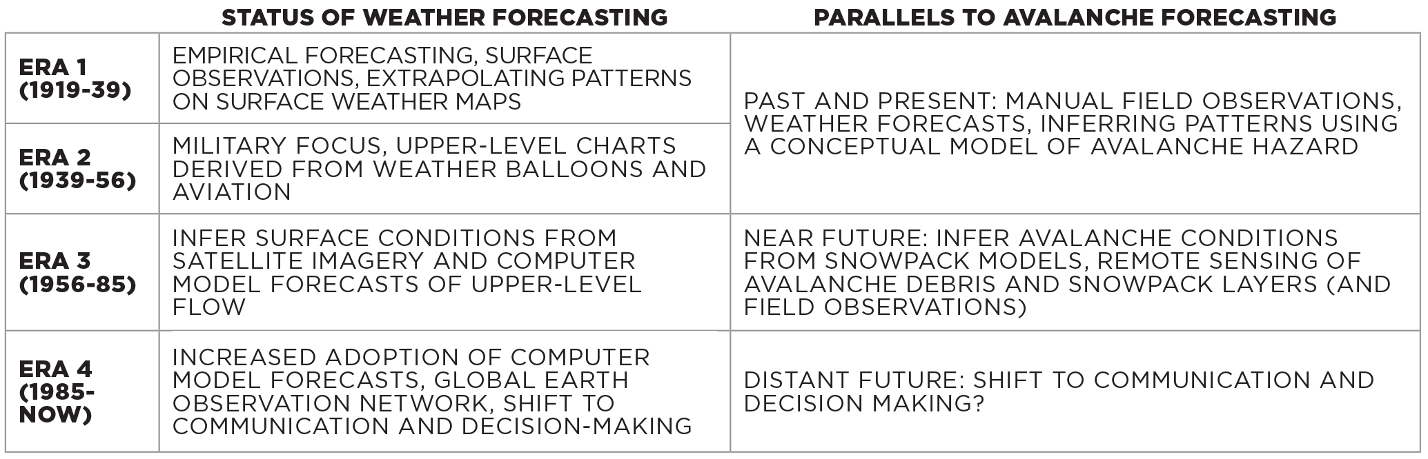
WEATHER FORECASTING HAS RADICALLY transformed over the past century. In the 1920s, field observers reported current weather conditions back to meteorologists, who would draw up weather maps and extrapolate the weather for the next few days. Fast forward 100 years and precise forecasts are possible in mountainous terrain thanks to a global network of earth observations, advances in scientific understanding, and some of the most powerful supercomputers in the world.
This raises the question, will avalanche forecasting head down a similar transition from field-based to computer-based work?
Certainly not anytime soon, but some form of technological progression is inevitable. The transition for weather forecasting took decades, starting around the time of the Second World War. Growth in aviation enhanced our interest in the atmosphere, that in turn changed our perspective of the weather. In the decades that followed, space exploration led to weather satellites that gave us an even broader view of the atmosphere. Then, early computers began crunching numbers to help with these extrapolations.
Despite these technologies, weather forecasting remained deeply rooted in experience-based pattern recognition for several more decades. By the 1970s, computer models began giving reasonable upper air forecasts (such as jet stream forecasts), but the Second World War-era style of human-centric forecasting still prevailed. the tides turned in the 1980s and 1990s when computer forecasts became more accurate and forecasters eventually learned when they
could and could not trust them. Trust in the ability of computer models to accurately predict weather continues to grow.
Avalanche forecasting currently relies on manual field observations and experience-based pattern recognition comparable to methods used by Second World War-era weather forecasters. However, over the past decades, the avalanche research community has developed remote sensing and computer modelling methods that have similar potential to observe, understand, and predict avalanche conditions. These technologies are at a similar status to weather forecasting technologies from the 1960s or 1970s. New methods are becoming available, but we don’t really know how to implement them into daily work.
As we saw in weather forecasting, these barriers were eventually overcome as the technology improved. We can speculate what a future avalanche forecasting system might look like by looking at how similar technology transformed weather prediction.
OBSERVATIONS AND PREDICTIONS
Modern weather forecasters use interactive dashboards that combine field observations, satellite imagery, and computer predictions to form a comprehensive picture of current and future weather conditions. Could this be what our workspaces look like in the future? Maybe instead of simply reviewing field observations from your own and neighbouring operations, a future avalanche forecasting tool will combine these observations with automated maps of avalanche activity, virtual snow profiles, and computer predictions of future conditions. to help form a more comprehensive picture of avalanche hazard. Even if it’s speculation, it’s important to understand the potential for technology to change avalanche work so we can shape it in a way that we all benefit.
The technologies impacting weather and avalanche forecasting broadly fit into two categories: ones that observe the conditions and ones that predict the conditions. In terms of observing conditions, weather satellites were the game changer that allowed us to expand from point observations to continuous spatial coverage. The same thing could happen with avalanche and snowpack observations. Networks of detectors that sense vibrations from avalanches are already installed, and recent research out of Europe has shown impressive accuracy in detecting avalanche debris in near real-time using radar-based satellites. Testing in Norway has found these satellites, which can even see through clouds, can provide updated daily maps of avalanche debris with complete spatial coverage across mountainous terrain. Imagine being able to see map of every avalanche that ran in Canada over the past 24 hours!
Remote sensors—from either satellites, aircrafts, drones, or on the ground—can also tell us about the snowpack. Deriving maps of snow-covered areas is already straightforward, but there is an increasing ability to sense snowpack layering remotely too. There are still many hurdles to getting actual x-ray vision into the snowpack—detecting thin weak layers is difficult, wet snow and crusts create a lot of errors, and all remote sensing technologies struggle in steep complex terrain. Advances in remote sensing are happening quickly, but most likely will need to be supplemented with other information to give us the best possible picture of avalanche conditions.
This is where prediction comes in. Our understanding of weather evolved in the 1920s with improved theories about the 3D structure of frontal systems. This didn’t have much impact on forecasting until several decades later when these theories were applied in computer models. This has become the backbone of modern weather forecasting.
Similar advances in snow science over the past decades have enhanced our understanding of how weak layers form, how avalanches release, and how they move downslope. The latest theories about snow microstructure and fracture mechanics are being implemented into computer models that simulate both the evolution of the snowpack structure as well as the movement of avalanches once they release. Could these models eventually have as much predictive power as weather models?
VIRTUAL SNOW PROFILES

A VIRTUAL SNOW PROFILE CONTRASTED WITH A HAND DRAWN ONE // SIMON HORTON
One promising forecasting application is computer models that simulate snow profiles with weather and terrain data. Some European countries started testing virtual snow profiles in the 1990s and Avalanche Canada started testing similar products 10 years ago with a focus on remote, data-sparse areas where the models could be driven with weather forecasts. (You may have seen these virtual profiles on ARFI.) Since their inception, the consistent question is, "How accurate are they?"
After 10 years of developing and testing these models for public forecasting in Canada, our impression is they provide a reasonable picture of general snowpack patterns, at least at some of the locations some of the time. Similar to how early weather models provided semi-realistic jet stream forecasts, the latest snowpack models can provide some big picture context to what is happening in the snowpack.
Weather models started being useful for big scale processes and we can expect snowpack models to follow suit. Rather than treating virtual profiles as slope-specific information, we can use snowpack models to look at regional differences in snowpack structure. For example, a surface hoar layer may form in the northern Monashees but not the southern Monashees because a storm tracking along the U.S. border causes too much cloud cover for surface hoar to form. Current applications of virtual snow profiles can already resolve some of these big-scale patterns. A focus of the avalanche research group at Simon Fraser University is developing ways practitioners can visualize and understand these patterns.
Weather models eventually grew from basic advisory tools to predictive powerhouses. A big reason they became more accurate in the 1980s and 1990s is they were fed with more observations of current atmospheric conditions. Uncertainties about the current weather (such as the initial conditions) is one of the main sources of errors in weather models. Over the past few decades, the amount of observations that could be collected by satellites, radars, and airborne sensors has exploded. Once the initial weather conditions are processed, computer models simply apply the laws of physics to figure out what will most likely happen next.
Similarly, the biggest source of uncertainty in snowpack models is figuring out when, where, and how much it snows. The most realistic virtual snow profiles are the ones at locations with good snowfall measurements or forecasts. Once snow is on the ground, the laws of physics do a pretty good job of figuring out how it evolves, but measuring and predicting snowfall is still hard, and even the best measurements and models currently fall short. We can expect to continue getting better at knowing how much it snows with better weather forecasts and observation networks. From there, we can get better at predicting the snowpack structure.
MERGING OLD AND NEW

LEFT: METEROLOGY SERVICES OF CANADA RADAR IMAGE OF WESTERN CANADA // MSC
RIGHT: WEATHER MAP FROM SCANDINAVIA FROM 1874 // WIKIPEDIA CREATIVE COMMONS
Early weather models were considered advisory tools. Meteorologists would check their own jet stream forecasts against the computer forecasts to increase confidence in their predictions. Computer-based systems were brought into the loop to augment human capabilities rather than replace them. They were a thinking tool. What really changed the day-to-day operations of meteorologists was the development of tools that merged old methods with the new technology.
In the late 1990s, interactive computer dashboards were developed that allowed forecasters to visualize field observations, satellite imagery, and computer model forecasts all in one place. Bringing different sources of information together allowed forecasters to get the most complete picture, filter through all the information, and weight each type of data according to its strengths and weaknesses.
The InfoEx is a current example of a forecasting tool that helps us build an understanding of avalanche conditions based on field observations and analysis by fellow professionals. Perhaps a future version of the InfoEx could combine the information we currently use with satellite maps of avalanche debris and some fusion of a remotely-sensed and computer-simulated snowpack visualizations to give us a more complete picture of avalanche conditions. If designed effectively, such a tool should help us assess hazards faster, more efficiently, and more accurately.
There’s lots of talk about machine learning and losing work to automation. This is scary for a community that looks to the mountains for an escape from the chaos of the digitized world. These emerging technologies could change aspects of avalanche work, but they won’t automate it. The transformation of weather forecasting took decades, billions of dollars, and major international collaborations. Even with that, weather is (probably) still easier to predict than the delicate slope-scale processes that cause avalanches. Plus, meteorologists still have jobs—they just spend less time analyzing data and more time communicating and making decisions.
The hope is that integrating new technologies will improve our hazard assessments so we can focus our time and energy on risk mitigation. Computers are great at pattern recognition—better than humans in many fields—but thankfully avalanche forecasting is more than that. Computer predictions will need to be verified, interrogated, and interpreted by humans. Ultimately, the complex mitigation decisions are up to us. Field work may become more targeted, where the computer system identifies the greatest uncertainties that need to be resolved by sending field teams to answer specific questions.
There will certainly be a learning curve, perhaps a slow one, where we gradually learn what technology can offer. We should all be engaged to learn about how these technologies work and, more importantly, have our say on how they should be implemented so we can make informed decisions about the future of avalanche forecasting.
REFERENCES
Benjamin, S. G., Brown, J. M., Brunet, G., Lynch, P., Saito, K., and Schlatter, T. W., 2019. 100 years of progress in forecasting and NWP applications, Meteorological Monographs, 59, 13.11-13.67.
Eckerstorfer, M., Bühler, Y., Frauenfelder, R., and Malnes, E., 2016. Remote sensing of snow avalanches: Recent advances, potential, and limitations, Cold Regions Science and Technology, 121, 126-140.
Horton, S., Nowak, S., and Haegeli, P., in review. Enhancing the operational value of snowpack models with visualization design principles, Natural Hazards and Earth System Sciences.
Morin, S., Horton, S., Techel, F., Bavay, M., Coléou, C., Fierz, C., Gobiet, A., Hagenmuller, P., Lafaysse, M., and Ližar, M., 2019. Application of physical snowpack models in support of operational avalanche hazard forecasting: A status report on current implementations and prospects for the future, Cold Regions Science and Technology, 102910.


